
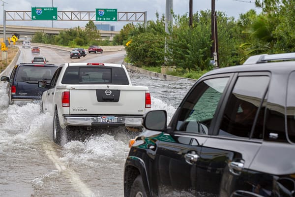
The famous line goes that Texas is the land of perpetual drought, soaked by occasional devastating floods. In 2021, for better or worse, floods visited Texas more than drought. The west Texas town of El Paso endured several flood events this summer. In early July, an unnamed weather system soaked coastal communities between Corpus Christi and Houston. September brought Hurricane Nicholas, drenching Houston. And in August, an intense rainstorm in central Austin flooded the State Capitol Extension.
Looking forward, we can expect floods to get worse. And we need to be prepared.
A recent report issued by Texas 2036 and the Office of the Texas State Climatologist at Texas A&M University reveals that, in addition to other meteorological maladies, Texas’ flood risks will intensify between now and 2036, when Texas celebrates its bicentennial. According to the report, Texas’ average temperature will increase by three degrees compared to the late last century. This temperature increase will contribute to greater rainfall intensity, meaning higher rain amounts in shorter periods of time. And expected extreme rainfall intensity will increase by 6-10%. Moreover, the odds of extreme rainfall events will increase by 30-50%.
More extreme rainfall events mean bad things for Texas’ flood-prone areas. According to the report, the more extreme rainfall events, the higher the likelihood for urban flooding. By 2036, the expected frequency of urban flooding will increase on the order of 30-50% when compared to the last half of the last century. Many major metropolitan areas of this state, including Austin, the DFW Metroplex, Houston, and San Antonio could be affected by this increased flood risk.
While Texas 2036’s extreme weather report describes the likelihood for more extreme rainfall and flood events, another report released by the First Street Foundation provides a clearer picture of how destructive those events can be. First Street’s report looks at the percentage of residential and commercial properties and miles of roads subject to flood risks. In addition to these factors, First Street’s analysis evaluates the flood risks for local infrastructure, which includes first responder stations, electrical power facilities, and water and wastewater plants, and for social infrastructure, which includes government buildings, schools, and churches. Combined, First Street’s data provides an alarming look at how much flood damage — including swamped homes, submerged streets, power outages, and closed schools — communities can expect during extreme weather events.
Currently, nearly 1.1 million Texas homes, 172,143 miles of roads, 86,899 commercial properties, 2,840 infrastructure facilities, and 5,223 social facilities are at risk of flooding according to First Street’s data. The table below lists the top ten Texas counties with the greatest proportion of operational risk due to flooding.
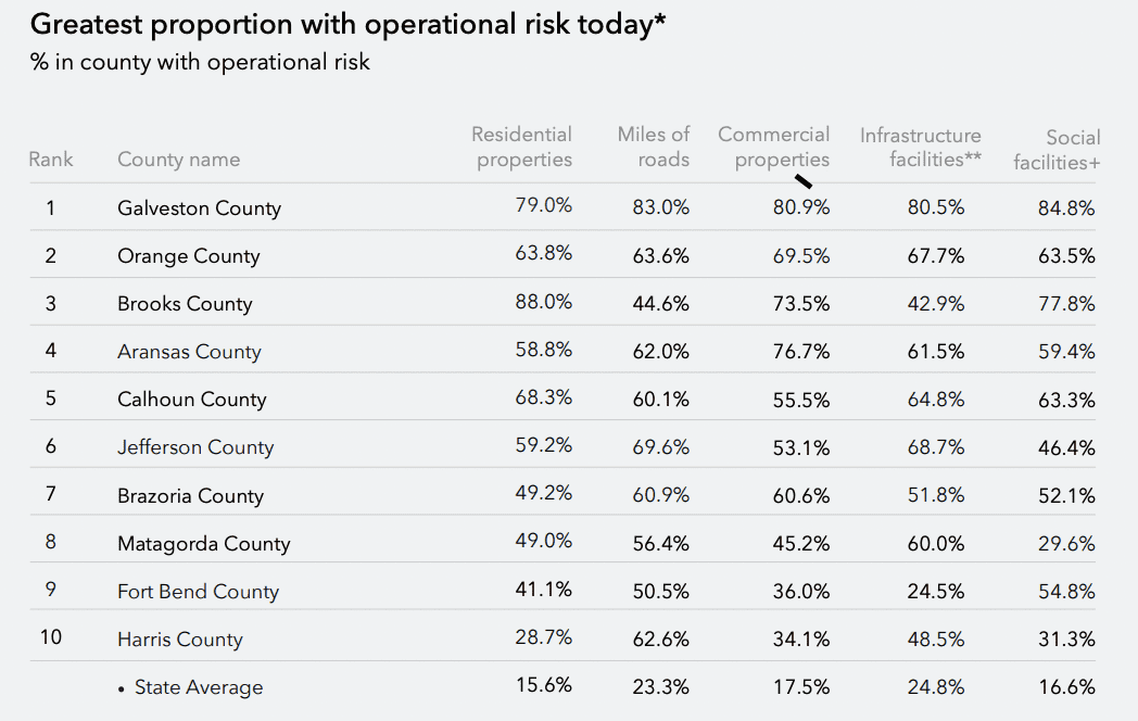
Of these ten counties, seven are located along the coast. Two of those counties, Harris and Fort Bend, rank among Texas’ most populated. Galveston County tops the chart with the greatest combined proportion of properties, roads, and facilities subject to flood risk. Harris County, home to Houston and Texas’ energy hub, also ranks high in flood risks. Nearly 50% of the infrastructure facilities in the area, which include electrical power and water treatment facilities, are at risk of becoming inoperable. Further, nearly two-thirds of the county’s roads are at risk of inundation during an extreme weather event.
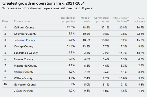
In addition to looking at current, existing flood risks, First Street’s report evaluates Texas’ growing flood risks between now and year 2051. These data ar
e consistent with the findings in Texas 2036’s extreme weather report that project an increase in the probability of intense rainfall events and urban flooding. Looking at First Street’s analysis, by 2051 an additional 84,856 residential properties, 5,608 miles of roads, 5,033 commercial properties, 201 infrastructure facilities, and 343 social facilities will be at risk of flooding.The table to the right, Greatest growth in operational risk, 2021-2051, lists the top ten counties facing the greater flood risks over the next 30 years. All of these counties are located on the coast. This risk growth is attributable to the expected rise in sea levels between now and 2050.
Although Texas’ coastal counties will see the greatest increase in flood risks, First Street’s data indicates that inland areas may also endure more flooding than they have in the past. For example, by the year 2051 nearly 39,000 more properties in Harris County will face a 100-year flood risk. Other areas that may expect increased flood risks include the Rio Grande Valley, San Antonio, East Texas, the DFW metroplex, and the Austin area.
Taken together, First Street’s flood report and Texas 2036’s extreme weather report point towards more, bigger flood events that will damage homes, businesses, and critical infrastructure. The essential observation here is that floods will get worse. Fortunately, in 2019 the Texas Legislature approved a state flood planning process and established a fund for financing flood control and mitigation infrastructure. In order for these programs to be effective, however, state legislators and water planners must incorporate extreme weather data into the planning and development process in order to scale new flood control and mitigation projects to meet future requirements. The floods in our future may be worse than what we have seen. We need to build our projects accordingly.